 I wake and think that it is probably 5:00 am, or so. I check
my watch and it is 12:30 am. I am terrified, as I feel that it is time to get
up and get going. I look outside my tent and see a full moon, which is electrifying
the landscape as Andy had predicted the day before.
I wake and think that it is probably 5:00 am, or so. I check
my watch and it is 12:30 am. I am terrified, as I feel that it is time to get
up and get going. I look outside my tent and see a full moon, which is electrifying
the landscape as Andy had predicted the day before.
I lay
awake in the tent noticing that I was too hot to get into the down sleeping
bag, until a blast of cold air sent me into the cocoon. I sewed the down sleeping
bag when I was 20 years old, and added extra down in the feet section of the
bag, which makes it very warm down into the teens. The pattern of silent calm
hot, and then a blast of cold air continued throughout the night, which made it
impossible for me to get any sleep until about 3:00 am. I finally fell asleep,
only to wake at 7:00 am, and find that the temperature is now 59 degrees.
I get up and
check my water status, only to find that I had about an inch of water left in a
little water bottle, and whatever was left in my hydra-pack. I decide to forgo
any cooked breakfast, and to eat the second half of an energy bar from the day
before, along with a gulp of water. I want to conserve the water in the event
of an emergency during the day. I close down, and pack the tent, and then
literally pray that I not have any problems on my decent. The night before,
John went on about how difficult the trail up was on his car. John thought that
he really should not have made it, but somehow he make the campsite. I descend
the rugged rocky road, just taking it one section at a time.
As
I get to a level area, I stop the bike and take a small composure break before
pressing on. There are areas where the slope is so inclined with loose rock,
that you must let the bike go, only to break when I land on areas that will
allow the bike to grab ground and stop. I let the engine do most of the work on slowing the bike, and use both brakes to keep the bike’s speed in check. I
get down to the kilns and do a little gig, as I am happy to get past the this section of trail.
I continue on the gravel road past the kilns, which are once again more difficult
than I remember for the last trip.
I
arrive at the paved road and swish down the slopes until I come to the
maintenance areas at the bottom. At the
maintenance areas are springs that flood across the road, and there are many
animals on the road. I see about 10 rabbits of all sizes, and then I see what
looks like a baby mountain lion jogging of the road. I think that my goPro
captured the scene, but I have not checked as of yet.
I arrive at the Trona
cut-off road, which has been closed most of the time that I have been coming to
Death Valley. The road sign says “Rough Road”, but I have never been on the
road, and I am just dying to see what it is like. The road is rough, but
nothing bad, and eventually connects with the main road to Trona. I get a few
miles down the road and run into the gravel road to the Ballarat ghost town. The
town of Ballarat was founded in 1897, and had 500 residents, 7 saloons, a post
office, a morgue, and a jail. Eventually, the mines in the area started to play
out and in 1917 the post office closed.
I start down the gravel road towards Ballarat at 40 mph, confident in my
ability to navigate the seemly easy gravel road: I sit with my legs crossed,
a martini in my right hand, and a cigar in my left hand.
I get about a half
mile down the road, and encounter deep pebble sized gravel. I lose control of
the bike, and the next thing I know, I am laying face up on the gravel
road about 10 feet in front of the down bike, with my legs folded under me. My
first thought is “Am I okay?”, because it all happened so fast. I manage to stand, and do not detect any
broken bones or bloody areas. I survey the carnage, and find that the bike is embedded
into the sandy walls of the road, the windscreen has been broken into three
pieces, and both rear view mirrors are impaled into the road further, up
stream.
There are other miscellaneous
parts strewn around gravel road, which I immediately pickup and stick in my
pockets. My second thought is "Wow, I really need to get some off road riding education and training".
The bike hit the road on the left side, trapping my left ankle, then
slammed into the wall of the road, which caused the bike to flip over to its
right side, ejecting me forward of the bike, and causing me to slam my ribs and
head into the road.
I immediately,
start the disassembly of the gear, which I am now quite used to, and pile the
pieces next to the bike. I dig out the sand around the tires so that I can push
the bike backwards, and out of the wall of sand. I once again stand the bike up,
and try starting it. The bike does not start, and I am now deeply concerned, as
I have not seen a car at all today. I check the bike, and discover that the
kill switch was turned off during the crash. I flip it on, and the bike
immediately starts. One thing about this bike that I really love, is it always
starts right up, regardless of altitude, rain, or temperature.
I remove the remainder of the broken windscreen,
load the bike back up and hit the road. The blast of fresh air without the
windscreen, actually feels good in Death Valley. Undeterred by the early days events, I am determined
to take the most fun route home, which passes by Joshua Tree, through Idyllwild,
and over the Ortega highway.
I take the Romona Expressway home, and as I get to
the cow smelly section, the highway patrol diverts the traffic off the main road,
and through a dirt road, that is used to support the work on the fields, and
livestock areas. The dirt is a fine dark dirt, that creates a smoke like fog
when a car drives by.
Now imagine, that there are 30 cars in front of me, as
well as oncoming cars driving down this same road. There were times where I
could not see a thing, and I ran the risk of hitting a hole in the road, and
being thrown like earlier in the day: I was not a happy camper to suffer this
indignity, at the end of my ride.
The
road bypass scene was a horror story, as you could see people’s faces of concern as they passed
you in the fields. I do not think anyone
knew the route, or when we were going to get out, but finally after about 2
miles we hit a paved road, which was on the other side of the supposed accident
scene. The rest of the ride was without incident, and I arrived home at 6:45
pm.
I wake and walk across highway 50 to breakfast. As I am walking across, I look up a block and see a herd of deer cross the highway. A couple of trucks slowed to let the deer pass safely. I finish breakfast and hit the road.
As I am leaving town I finally see the US 50 sign that says “The loneliest Road in America”. The last two times I passed through town, I missed the sign and have been kicking myself ever since. As I am 40 miles out of town, I see a man dressed nicely, pushing a full baby carriage, with the top down. This sight is really strange in that we are about 100 miles from the next town, and there are no ranches or houses out on the road. The guy must have a few loose screws, or there is something nearby that I do not know about, but then why would someone walk a baby carriage on US 50?
The conditions and road are just perfect for the first time in two weeks. There is no wind, the temperature is about 60, and the sun is out. There is not a trace of smoke as I look to the mountains. Highway 50 is about as good as it gets, and I am riding it.
I ride for a couple of hours and turn on to a dirt road which I take for about 7 miles. I am heading to the Spencer Hot springs. I decided to go to the hot springs this time, because I have the off-road tires on, where previously I did not.
The road is gravel and when you get to the hot springs it is gravel and dirt. The hot springs are on BLM land, and not maintained by the BLM. Some of the locals have done some improvements over the years to make it enjoyable. I am not sure where the hot springs actual are, but I see a van parked to a water container.
I decide to stop and check it out, and ask the van owner if he knows where all the spring locations are. I park the bike and walk around to the other side of the van, and there is Andy in all his glory walking towards me waving. Andy is a red head with freckles, who I would guess to be 65 years old. I ask Andy, “Where are all the other springs, and is this one here a good one?”. Andy replies that there are about 5 springs dotted over the landscape, and this one is a great one. The road only goes up from here, and I do not really like the look of the road, so I opt to stay here. I ask Andy “Going nude appears to be acceptable here?”, which is yet another stupid question, because Andy is standing in front of me in his buff, casually having a conversation. Andy replies, “Yes, in fact I went naked on a two mile hike this morning”.
I strip down to my bike shorts, which are essentially tight swim trunks, and jump in the hot tub. The temperature is just right, as Andy had diverted the tube carrying raw hot water out of the tub earlier to cool it down. You want the water hotter, then put the tube back in the tank. I soak for about 10 minutes, while Andy goes for yet another hike. I get out, and get dressed as Andy, and another gentleman, with a dog comes back to the tub and start a conversation. Andy says that he got a music degree at UCI, the third year of the school’s existence, and that he was just back for the last two weeks visiting his brother in Denver. Andy spent the night at the tub, with three other groups, that have left earlier. It must have been quite a party late last night at the hot tubs. I had hoped to camp at the tubs last night, but could not get here in time due to construction and the storm. I finish getting dressed, thank Andy and the other guy, and hit the road South, all the while the wind and temperature increase.
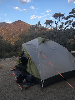
The wind starts getting pretty strong and impacts my mileage, but I get to the town of Beatty on the outside of Death Valley at about 3:00 pm. I suit up for a hot one and head down into the Death Valley, where I clock 114 degrees at the bottom. I then head toward the Kilns and Mahogany flats, which is at 8,050 feet and the highest campground in Death Valley. Mahogany Flats is located in a juniper forest in the Panamint mountains.
Once I get just South of the Kilns, the road turns to heavy gravel. The road appears much more difficult than the last time I was on it about 5 years ago. I head up the gravel road, which now has a steep incline that starts to turn into loose rocks. I get up pretty far, and concerned that I missed the campsite, I start to move to the side to stop, which is a huge mistake because I hit a rock, and I immediately drop the bike on the incline.
The good news is it is a great spot to drop the bike, because it is just off the road and smooth, but still on a good incline. I strip the bike and hoist it up as before, and continue on the road, only to find that the campsite is just around the bend. The 16 campsites, or so are totally empty. Just me once again, in my own campground.
The views from the campground are of the park’s valley 8,050 feet below. The winds are gusting, but I already have my down jacket on as the sun has just set over the next ridge. Could be a windy night, although I doubt it will rain: but you never know. Unfortunately, I did not secure my main water source in the form of a platypus water bottle on the bike very well, and it must have fallen off during the ascent. I do have a couple of small water bottles, so I will not die, but I may not boil or cook something in the morning as I may not have enough water left after the night. We will see how I am feeling. There are not any animals here, other than one small bird that is walking around the campsite looking or food.
As I sit at my picnic table working my blog, John walks into the campground. John is planning to go to Rogers Peak at 9,990 feet the highest spot in the part tomorrow with a telescope, and says he was in Badwater, the lowest point yesterday. John is originally from Atlanta, and now lives in Nashville. This is his first time on the West coast, and loves what he is seeing.
I point to the last campsite, and suggest that John take it, as I believe it to be the premiere location, with a view. John is off to check it out and stake his claim. The little bird is still meandering around the campsite looking for food in the dark.
I wake to find the temperature at 35 degrees. After a hand-freezing pack-up, I successfully navigate back down the gravel road to the main highway and head South.
The Salmon river continues to meander flowing North.
I am traveling South, but something feels wrong and I get the impression that I am traveling downhill, but the river is flowing North: must be an optical illusion. The river takes us to a small canyon that is densely packed with trees, and it feels even colder. I would have used the heated jacket, but I packed it away a few days ago. I finally pop-out into a prairie area that I cross for about an hour, and then the road goes over a mountain. Along the way, are offers for scenic viewpoints, which I decline since the smoke prohibits seeing too far. There have been many viewpoints I would have loved to stop at over the last few days, if it were not for the smoke. I enter Ketchum and am amazed at how upscale the town is. I was expecting a sleepy little town, but instead find a touristy ski resort town. I want to get some breakfast so I start into town looking at Yelp for guidance. The restaurants I see are very much upscale “che-fee-fee” restaurants, which are not what I was looking for. I stop the bike in a clearly defined “no parking” stripped zone, to check Yelp for another breakfast option. While I am pondering the iphone screen, I hear a voice say “Do you need directions?”. I look up and there in the middle of the street is a really nice looking police SUV, and an officer looking at me. Realizing that I am looking bad, in both my garb and my parking spot, I say “Yes, I am heading South”. Which is kind of a stupid thing to say since the highway comes in fro the North and exits the city to the South.
If I came in from the North, then all I would need to do is continue on. “Do you need to know how to get to Twin?” asks the officer. I respond with “Yes, that is it”, and he says “you get back on the 93 and head South, you cannot miss it”. I thank him profusely for the information, start my engine and take off South. I get to Twin Falls and find that just as you get there a huge ravine appears, much like what you encounter coming Southbound into Tao, New Mexico. You are just traversing the prairie and suddenly the earth gives way to a huge gap. I get about an hour South of Twin Falls and stop at a rest stop to get a snack, and check on the oil level on the bike. In order to accurately check the oil level I must put the bike on the maintenance stand, and in order to get the bike on the maintenance stand I must take off the pannier, because they are too heavy to get the bike up on.
As I am sitting down, Roger an older guy dressed in black pants, black tee shirt, pony tail and tats walks up and says “You okay, you having bike problems?” I tell Roger that I am just checking the oil, and there is no problem. He then tells me he is a bike guy, but is driving the motor-home in front of us. Roger then says “I was not too far from here about 20 years ago riding with my friend, and I pulled over to wait for him. I waited and waited, and then a lady pulled up in a car and asked if I was waiting for another guy, and If I was, then he was back about a mile in the middle of the road. I went back, and there he was with an electrical problem and he had a rock on the panel, and was sitting on the rock.” Before I could get better clarity on the road, and the electrical panel story, Roger’s wife Gloria walks up with their dog, as she was having a hard time trying to get the dog to “go”. “Are you telling a Pete story?” Gloria cheerfully chimes. In a downward beat, Gloria then continues with “Oh….Pete died yesterday” as she looks at me. I tell them that I am sorry, and they tell me they have been on the road telling each other Pete stories, and reliving the good old days when they would ride these same roads with Pete. Gloria hands Roger the dog, and then heads off to do her own thing. While Gloria is gone, Roger tells me that he once went way up North in Alaska on his Harley. “I only saw about 5 Harleys way up North, mostly it was BMWs” says Roger. “I ran into another Harley guy at a campsite, that was waiting on a new chain to be delivered, and he was on his third chain, and boy it would be expensive to have a chain delivered to a remote campsite. I was hoping that was not going to be me next” says Roger. The last thing Roger told me was that I needed to check out Shoshone Falls, as it was as great as Niagara Falls. I told him that I had never heard of Shoshone falls, but I would be sure to check it out next time through. As I continued on, the temperature got to 95 degrees and the smoke slowly dissipated. By the time I got to central Nevada the smoke was all but gone, thanks to a wind coming out of the South. At one point, I was riding and saw what looked to be a gliding bird in the air above and in front of me. As I got closer, it looked more like a glider. Suddenly, I realized it was a tumbleweed, suspended in the air by an invisible dust devil. But, by the time I realized it was a dust devil, it was too late, and I was in it being jerked around the highway. The landscape was classic Nevada sagebrush, with mountains in the background and nothing in between. My plan for the night was to camp near Austin, Nevada, but due to several heavy-duty road construction projects, my progress was greatly diminished. As I was approaching Ely, a great and dark storm was coming out of the South. The winds were the strongest of the trip, as great, or greater than the winds I encountered in the Yukon. At his point, I could only achieve a speed of 65 mph, due to the intensity of the head-winds. There was heavy blowing sand, so I decided to forgo the camping and find a hotel in Ely. I was lucky to get a room at the same hotel that I had used two years ago on my highway 50 ride. Overall, there were tremendous landscape and temperature changes on this 455 mile ride through Idaho and Nevada: a good day.
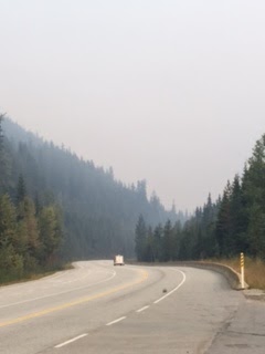
I wake, get some breakfast and check how the
smoke situation is doing outside: it is bad.
I hit the road and although it is 10 am, the sun is just an orange globe
in the hazy sky.
I travel south on the 93 until I hit Missoula, Montana where I
grab some lunch. I continue south thinking that the road will now change into a
winding mountain road with little, or no cars, but quite the opposite is true.
There are tons of cars going both South and North, and on both sides of the
highway are industrial buildings. I stop to get some gas, and as I am working
on the gas cap I hear a diesel pull up behind me and out of the dodge pickup
truck steps Jim, who is about 75 years old and wearing rancher garb. “What part of California are you from?” asks
Jim. I tell him that I am from Orange County. “The last republican holdout.” Spouts
Jim. “I was born in Alameda, and went to school at Berkley. Alameda was a good
place to grow up” Says Jim. Jim is
filling a gas can and says this Suzuki ATV only gets about 15 mpg. I wish Jim a good day and head back on my
way. The industrial view goes on for
about 2 hours and finally, the canyon walls narrow, and the meandering Salmon
river springs into life. The Salmon river was use by Lewis and Clark on their
expedition across the West, and there are many historical markers describing
their efforts. I get about an hour past the town of Salmon, and decide to ride
to a BLM campground that is about 7 miles off the highway. The road quickly
turns into gravel, but thanks to my new-found Dalton highway skills, and my off-road
tires, I make haste to the campground.
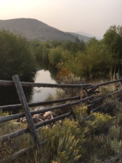
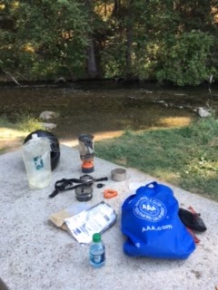
I
pull into the campground and find that I am the only one here. There are two
picnic benches, a beautiful little babbling stream, an outhouse, and a water
pump. I was really expecting no water on such a remote and small campsite. I
start working on the bike, as always and a little white car pulls up into the
campground.
I am thinking that I now have neighbors, but Tom jumps out and
assembles his fishing pole. As he is
walking by, I ask Tom if there are really fish in this little steam and he says
“You bet, there are rainbow, brook” and a couple of other trout that I cannot
recall. I then say “They stock the
stream?”, and Tom says “No, they are all native.”, which does not make sense to
me, as I recall that only brook trout are native to most these areas? Tom heads off and I eat dinner. About an hour later, Tom comes back from the
stream, and I ask if he caught any fish, and he tells me he caught about 6 or 7,
with the largest being 7 inches long. I do not see him carrying any of the
fish, so I assume he did a catch and release. We start talking and I find out
that he is volunteering at one of the local state parks. He has been here six
months, and prior he was down near Death Valley for six months. They have been
full time living in an RV for a year, and he is loving it. Technically, they
are citizens of Texas, which allows people that live in an RV to only have a PO
box. Tom used to work at the University
of Arizona in Facilities Management.
I told him I received my degree in
Landscape Architecture at UofA. Tom says
that the new building housing Landscape Architecture was a disaster, because they
put no insulation in the roof, as it was to be green, and then they tried to
plant vines to go up the side of the wall, but the extreme heat killed them
all. Tom says his wife is a biologist, and loves this area because of all the
diversity. Tom says that he does miss
other areas, and that the closest thing to ethnic food in the area is pizza. Just
then Gloria comes back from the other side of the road. Tom asks if she saw
anything new, and she says “Na”. Tom
asks if I am carrying a gun, and I say “nope”, although one of the rider club
guys from Montana wanted me to carry one. Tom laughs and says that the locals
always ask him if he is going to take a gun when they go for a walk, due to
rattle snakes. Tom says “All you need to do is walk around them. You don’t need to kill them.” Tom and Gloria then pack it in and head on
out. I am now all alone in my own private Idaho. The area quickly grows dark and cold, as I am
in a canyon. I climb to a little hill in
my campground to survey the area, and find that there are no lights at all. Tom
says there are a few ranches up the road, but I see no indications.
I wake and find that it is rather cold. What a difference from yesterday afternoon, where I was wearing a short sleeve shirt. I decide to head back to Golden, since going West would take me too far out of the path of where I want to go, and the smoke appears to get worse as I head West. I stop at Tim Horton in Golden and find that there is a massive crowd in line. It take about 30 minutes for me to get what is essentially an egg MacMuffin. I gas up and get the heck out of town on the 93 going South. The road is nice, with no traffic going Southbound.
There are mountains on both sides of me, which probably explains why there is no rain. Death Valley is has multiple mountain ranges that prohibit rain from crossing over, and these mountains are probably acting in the same fashion as the Death Valley mountains. Visibility is about 95% as I start down the 93. I was thinking about doing the hot springs in Radium Hot Springs, as several people along the road suggested that the hot springs where the place to be. But, I arrive at Radium and find that it is yet another tourist trap. There are two cops in the 4 way stop intersection directing traffic. It is a mad house, with massive amounts of traffic. It appears that the traffic is primarily coming from the South and turning left toward Banff, and ultimately Calgary. I decide to not stop at the hot springs and continue down the road, all the while the temperature gets hotter, and the smoke increases. At one point I stop to make some mac-in-cheese at a rest stop with a nice stream, as the roadside restaurants looked too expensive, or not appealing. As I sit eating, another vstrom pulls into the rest stop. Being a good biker, I go up to the guy on the vstorm to say hello. I ask him what year his bike is and he says it is a 2003, which I immediately know is a dl1000, because they only started
making the dl650 in 2004. I blurt out my knowledge by saying “it’s dl1000”, and then immediately see it printed on the side of the bike. Vince, the biker appears confused and disoriented. I ask him where he is going and I get a very convoluted answer that sounds like he is going North, and maybe South, and will stop at his friends and stay there, etc. After his response, I gave up and hit the rest room, wishing him a great ride, wherever he may go. Along the route, I notice that I see a motorcycle about every 5 minutes. This is much different that what I experienced on the Dalton hwy, where I think I saw 5 motorcycles on the entire highway. In about 30 minutes, I arrived at the US border station. There where 6 really nice lanes with stops signs and a stop light at each one. What was odd, was I was the only one at the station. There was no other vehice, in front or behind me. I went to the first lane and waited at the light, which was red. I waited about a minute and nothing happened and then I decided to ride up to the window, fearing that maybe someone did not see me. I got there and was told that I should have waited until the light changed, and to never to it again.
I apologized for my mistake. The agent asked all the regular questions and then I told him I really expected to see more people.
The agent then said “Who would want to come to this” as he pointed to the smoke all around us. I agreed and was on my way. I rode on for about 30 minutes and decided to turn off the Garmin GPS in order to get it to sync right with the IPhone. The Garmin and IPhone have a very on-again-off-again relationship. Sometimes they work and sometimes they do not. This time I turned off the Garmin and it did not come back on. I then pulled over to the spot on a small park road, where I tried without success to get the Garmin to turn on. I remounted it, pulled the battery, and hit it.
Suddenly a fire pickup pulled up to me with two people. A lady was driving and she asked me if everything was okay. I told her that it was just the GPS and it was not mission critical.She
then said “You can get home, right?”, which I gave her the thumbs up.
She took off and I followed behind them using my IPhone as the
navigation device. The smoke was getting pretty bad by the time I got
to Whitefish, and so I decided to get a hotel instead of camping, as I
was not too sure sleeping in a camp fire was too healthy. I get to the
hotel room and read up on Garmin 595 issues and find that if you take
the battery out, and then connect the Garmin to a computer, then the
Garmin will come back to life. I try the recipe out, and it works: kind
of lame. Looking back at the last week, I find it kind of odd that I was in rain about 80% of the time the first week, and then suddenly there is no rain and the world is on fire with smoke everywhere.
I wake, and look outside to see what the weather is like. In the Gulf gas station next door, I see a lady walking around in shorts: It is warm here.
I check the weather report and it will be 80 here today, with no rain in the forecast. I load up the bike next to the hotel bench, where a guy is smoking a cigarette. I tell him that my gear was totally waterlogged last night, and as last night this concept appears quite alien to the people of the region. There must be such a line of demarcation, with those that get rain, and those that do not in this area of Canada. I ride an hour up into Glacier National Park and turn into Illecillewaet campground. I am determined to get a great camping spot today, and arriving at 11:30 am did the trick. There are those campers that come up for a Friday and Saturday, and leave on Sunday. The camp ground is at 5,399 feet and the temperature is great. There is just a touch of smoke in the air from fires, but coming up it got really bad, where you could see active fire areas with columns of smoke spiraling upwards. The smoke is very localized, as you can be in heavy smoke one minute, and then go around the corner and it is gone. The campground is at Rogers pass, the site of where the railroad used to pass by a magnificent chateau
during the gilded age, around the turn of the last century. I hike up to the ruins of the chateau, and there are many information displays on the history. The chateau was a stop on the Canadian Pacific Railway, and was of the highest quality facilities and dining. The railroad imported Swiss mountain climbers to lead people up the glacier, as the area was at that time the premiere mounting climbing location in North America. The railroad stopped coming in the early 20s and the chalet closed soon after: They tore the structure down a few years later.
I started doing a short hike and rain into an Austrian couple, Julia and Michael. The couple was coming back from the old railroad track that runs past the Chalet’s ruins. Michael stops me and asks “Are you not afraid of the bears?”. I ask him “Should I be?”. We joke around for a bit, and then they take off in the other direction. I keep going, and find that I am by myself. I start thinking about what Michael said about the bears, and grow uncomfortable going any further down the path. I turn back and start down a local path.
I walk some distance and again run into Julia and Michael on the short trail. Unfortunately, you cannot hike more than about a mile without a party of 4, due to the bears in the area. There are many signs warning people about the bears and what penalties will befall you, if you ignore the rules. We hike back to the starting point and I ask Michael if he wants to go back around the short loop, since it appears that you cannot go anywhere else. Michael laughs, and I go back to the campground and spend some quality time on the bike, cleaning areas that I have not looked at since the Dalton hwy. I find that somehow water has gotten into the “sealed” tool tube, and the tools and spare parts are covered in the Dalton hwy red clay mud. Lots of work cleaning up everything. I also continue to dry out my gear, as last night’s efforts were not efficient. My campsite is right next to the raging steam coming down from the glaciers, which produces a nice background noise. We are in the valley, so I anticipate that night will come early. The campground has great facilities, but no shower. Bear boxes are provided, since we are in bear country.
I wake and find that the rain has not stopped: it is coming down pretty good. I ride for a couple of hours getting soaked embracing new and interesting smells from the countryside. I then decide to switch out my gloves at a historical marker.
This was the exact site where the last spike was driven for the Grand Trunk Pacific Railroad that connected the East to the West, just outside of Fraser. As I change out the gloves in my pannier, the bike falls over to the right. I poorly parked the bike, and the new Givi large footprint stand adapter has raised the kickstand about ½ inch. I immediately start taking off the top bag and the left pannier, but I unable to get the right pannier off, as it is trapped under the bike. The bike is still heavy as there are many other items still on the bike, but using all my effort I am able to lift the bike up without rolling it. The preferred method is to roll the bike forward during the lift, but due to my poor parking, moving forward would have sent the bike off the road and into the mud, which would have turned into even a larger mess. The good news with the bike dump is that all the gear to keep the bike from getting damaged worked. The front panniers and hand guards kept critical components on the bike from hitting the pavement in the fall. I continue on for two hours until I reach Prince George, where I stop at my first Tim Horton’s restaurant of the trip. I had a great sandwich and a much-needed hot soup. I honker down and continue in the ever-increasing rain until I stop at a gas station near the foot of the mountains. I see a hotel on the other side of the road and contemplate finishing for the day, as the rain is just relentless.
I ride on for another 30 minutes and suddenly the rain stops after an amazing 6.5 hours, which must be due to the positioning along the mountain range. I continue on until I reach jasper, which is your classic town on the edge of a national park. People, restaurants, and traffic are everywhere: I cannot wait to fill my gas tank and head out of town. I head south on the 93 toward the ice fields. I am thinking that I will get a camp spot at one of the many campground along the 93. I stop at the first campground and ride through, but immediately know that I am in trouble as I can tell from the eyes of the people at the existing campsite. They have that “You are so out of luck” look in their eyes as you drive by. I give up on the campground idea after the first two campgrounds, and realize that I am now in big trouble because there is not a hotel around for a hundred miles plus, and it is already 6:00 pm. I check my Garmin and find that the largest bulk of hotels is in the town of Golden, which I will not get to until 9:45 pm. I bear-down and drive through the rest of Jasper park.
By the time I get to Golden, I am on my last legs. The last few miles going into Golden was torture. The highway goes from 100 kph to about 30 kph with twisting roads. I go to the Best Western and they are sold out, but Mildred at the desk calls several other hotels and finally calls Carrie at the Holiday Inn with one room left, but at a hefty price. I immediately take it as I am out of options, and you cannot sleep in your bike, like you can in a car. I check in and Carrie tells me they have not had rain for over 30 days, which is what Dustin told me earlier. I tell Carrie that my equipment is totally waterlogged and I must dry everything out: this idea is very amusing to people that have not seen rain in a long time. Carrie asks where I was that was raining so hard, and I tell her, but Prince George and the 16 appear to be a long way away for the people of Golden. I order pizza after I secure my room, and hit the sack after a 12 hour, 566 mile ride, of which half was in pounding rain.

 As
I get to a level area, I stop the bike and take a small composure break before
pressing on. There are areas where the slope is so inclined with loose rock,
that you must let the bike go, only to break when I land on areas that will
allow the bike to grab ground and stop. I let the engine do most of the work on slowing the bike, and use both brakes to keep the bike’s speed in check. I
get down to the kilns and do a little gig, as I am happy to get past the this section of trail.
I continue on the gravel road past the kilns, which are once again more difficult
than I remember for the last trip.
As
I get to a level area, I stop the bike and take a small composure break before
pressing on. There are areas where the slope is so inclined with loose rock,
that you must let the bike go, only to break when I land on areas that will
allow the bike to grab ground and stop. I let the engine do most of the work on slowing the bike, and use both brakes to keep the bike’s speed in check. I
get down to the kilns and do a little gig, as I am happy to get past the this section of trail.
I continue on the gravel road past the kilns, which are once again more difficult
than I remember for the last trip. 
 The bike hit the road on the left side, trapping my left ankle, then
slammed into the wall of the road, which caused the bike to flip over to its
right side, ejecting me forward of the bike, and causing me to slam my ribs and
head into the road.
The bike hit the road on the left side, trapping my left ankle, then
slammed into the wall of the road, which caused the bike to flip over to its
right side, ejecting me forward of the bike, and causing me to slam my ribs and
head into the road.